Vinni
Some words about weather systems in the south Pacific.
It is July, 2019 and I’ve just returned to Tahiti from Denmark. I enjoyed being in Denmark, especially the springtime weather and the long evenings where dark doesn’t arrive until late. Here in the Pacific, close ot he equator, we have almost exactly twelve hours of daylight and twelve hours of darkness. The expression, “nightfall” can be taken seriously out here. The change from light to dark is almost immediate.
We are at anchor just inside the reef at Tahiti. It has been overcast since I got here two weeks ago. We’ve had rain several days and yesterday the winds rocked the boat. But this has been the “calm before the storm”. The weather gods are send a high pressure from New Zealand towards us. It measures an unbelievable 1042 hPa, signaling gale to storm force winds and four to five-meter high swells.
If we have rocked the past week or so, this high-pressure will really get things rocking here in the anchorage and the winds works against the current running through here. We expect that we will feel like we are sailing on the open ocean – not lying at anchor inside a reef. There are many boats anchored here with no one on board, so we pay close attention and are wary of boats that have dragged their anchors. We don’t expect to leave Capri for the next two or three days. Even if it is possible to land a dinghy, one of us will stay on board.
The anchored boats are much too close to each other for these conditions and because of the limited room, most of us only 3:1 scope out on our rode (amount of anchor chain set out versus depth of the water). With the coming weather, we would feel more comfortable with 5:1 or even more. We have to trust to our anchor, set our anchor alarm and hope that our Mantus continues to bite in the loose bottom, consisting for broken coral and sand.
What is happening? In Denmark, we would be overjoyed with a high-pressure system. There it signifies warm, sunny windless days – every Danes dream for summer. Here, high-pressure systems act differently. They are formed south of Australia in the Tasmanian Sea and work their way over New Zealand and further east, affecting the weather in the entire Pacific and all the way north to Polynesia.
It has been difficult for Carsten and me to understand the weather systems out here. My “bible” Meteorology and Oceanography for Ships Officers by Mette Hundahl, is unable to help us. It describes the weather systems in the north Atlantic, not the south Pacific. Reading the Danish circumnavigator books, is also less than helpful. These give the impression that if you stick to the “Coconut Milk Run” following the trade winds across the Pacific, you will have sun, sun, sun and perhaps a few squalls. The wind is always from aft and you’ll spend all your time sailing downhill.
As the reader will already have noticed, that type of weather is not exactly what Vinni and Carsten have experienced so far. In other words – The Pacific doesn’t always live up to its name. It was only after we arrived in the Marquesas that I began reading some of sailing books in English. Here I could learn that the passage from Panama to the Marquesas was the easiest part of the Pacific. That passage is normally the longest passage circumnavigators face and is generally feared. The sailing from the Marquesas to the Tuamotus and further west is much more unstable and challenging. Why? I haven’t read anything about this in the Danish books, nor have I heard anything about it from the various speakers whose lectures I’ve attended.
Since we come out here, I’ve delved into a number of meteorology books and I’m beginning to understand the basics of what is going on. The following is a short and simple version of the weather systems. I’m only a sailor, not a meteorologist, so readers will hopefully bear with me.
The weather systems here make sailing more challenging here than in the Caribbean. We knew that the distance between island groups out here was greater than in the Caribbean, but we were not aware that the trade winds are nowhere near as stable here as in the Atlantic.
The trade winds of the north Atlantic tend to be very stable from mid-November (end of the hurricane season), generally blowing ten to fifteen knots from the northeast. In December and January, the winds increase, blowing twenty knots, occasionally as much as thirty knots (Christmas Winds). As spring arrives, the wind turns and comes from the east, decreasing in strength as April and May arrive. Finally, the wind will turn and come from the southeast.
The trades in the Pacific come out of the southeast, blowing ten to fifteen knots after the hurricane season ends (April). During May it will typically turn and blow from east/southeast, increasing to fifteen to twenty knots by July. But as we shall see below, these weather patterns are frequently disturbed by other pressure systems and the winds will increase proportionally to the disturbance. By September, the winds have again reduced to ten/fifteen knots and at end October, it turns and comes from the northeast, remaining there during most of the hurricane season. If you plan to avoid the hurricane season by sailing north to the Marquesas, you are well-advised to make the journey before November, otherwise you will almost certainly be battling both the winds and the swells the entire way.
Just as in the Caribbean, cruisers need to take the hurricane season seriously out here. The westward passage season is from May to the beginning of November and the prudent cruiser will find areas where hurricanes seldom come to spend the off-season. In the estern Pacific, the Marquesas are the safest place, although a number of cruisers choose to stay in Gmabier, Tuamotus or the Society Islands. Further west, New Zealand and southern Australia are “hurricane-safe”. No place is truly safe, all the above-mentioned, the Marquesas excepted, have been hit by hurricanes many times of over the past several decades. An alternative is to sail north of the equator and spend the hurricane season in the Marshalls or on Hawaii.
Cruisers quickly learn that out here that the main sailing challenge is not distance, but the weather. The motto most live by is; Plan for the worst and hope for the best. But always remember – Hope is not a strategy!
The Doldrums (ITCZ – Intertropical Convergence Zone) is a windbelt that lies between the two trade wind belts, one in the north Pacific and one in the South Pacific. When we crossed the Doldrums on our passage from Panama to the Galapagos, we did so without issue, mainly because we were far to the east and the Doldrums there were narrow. The Doldrums are generally feared because, as the name signifies, sailors are frequently becalmed there. The area is rife with squalls, lightning and thunder.
From Galapagos to the Marquesas, we sailed in the Humboldt current, which runs at one to one-and-a-half knots east to west and had trade winds blowing ten to twenty knots from east/southeast. We wondered, at the time, how the trade winds south of us could reach gale to storm force. Only later did we realize it was weather systems far away that determined this.
High-pressure systems play a major roll and disturb or more likely, reinforce the trade winds, resulting in the instability we experience here. The high-pressure areas are formed south of Australia in the Tasmanian Sea and move from west to east across the Pacific to South America. The wind is not able to cross the high Andes peaks and the high-pressure area consolidates and remains just west of South America, usually off the coast of Chile. A similar pattern is evident in the north Pacific, where the high-pressure forms because the winds are unable to pass over the Rocky Mountains.
This stationary high-pressure area, which lies south of the trade wind belt and has winds that rotate counter-clockwise, sends southeasterly winds up to the trade winds, thereby reinforcing them and increasing their strength. This augmentation can lead to trade winds of gale or even stronger force, as some of our cruising friends discovered when they were sailing bound for the Gambier. Carsten and I had a much calmer passage, bound for the Marquesas, since we stayed north of five degrees S. It turned out to be a wise decision to sail for the Marquesas and not the Gambier. We are also happy that we chose not to go to East Island and Pitcairn, despite these two places being high on Carsten’s wish list.
In the eight months we have spent on eh Marquesas, we have had stable weather, even in the rainy season (hurricane season). Regularly, we have weather fronts that pass over us – coming from the west. Why are these coming from the west, when we are in the trade wind belt where the winds come from the east?
The explanation for this seeming contradiction lies in the weather truly far to the south. As the high-pressure areas move from west to east south of us a low-pressure trough will frequently “shoulder” its way in between the high. These lows are formed far to the south, even as far away as Antarctica. This cycle occurs every seven to ten days. The low troughs, often containing diverse weather fronts are what disturbs the weak trade winds here in French Polynesia.
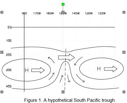
The illustration shows a low-pressure trough formed in the southern Polar region, “shouldering” its way between two highs. This cycle repeats every seven to ten days. (Illustration borrowed from Jim Corenman).
What does this mean in practical terms?
In practical terms, when the above happens, the trade winds die down, the temperature rises and it gets hot enough to be uncomfortable. You spend all your time in the shade. Finally the wind picks up and backs, coming out of the east and northeast as the high approaches. Once again, the wind dies and continues to back, coming now from the north and north west as the high passes and the low-pressure trough approaches. The wind then continues to back, coming from the west and thereafter south. Although the front occasionally brings a small warm front with it, it usually is only a cold front. Because of this, we now experience strong winds from the south that last longer than the northerly winds, lasting until the winds finish backing, ending where they began in the southeast. The trades will now blow undisturbed until the next high-and-low-pressure areas approach. The entire cycle lasts seven to ten days. All in all, there is no stable trade wind here.
But we still haven’t answered the question of why the various front approach from the west when we have an easterly trade wind. These fronts are controlled by the winds high up in the atmosphere blowing in the band between 10 and twenty degrees South (of the equator). The strong winds blowing high up control the weather fronts, because the trade winds are actually fairly weak in comparison and only blow near the surface.
The weather systems here in the Pacific have surprised us and we have yet to find a concise explanation in any of the Danish sailing books.
After gaining the above insight into Pacific meteorology, we realized that before leaving the Marquesas, we needed to have a clear picture of what was happening, in terms of the weather, near New Zealand and south of Polynesia. The local forecast for sailing to Tuamotus, for example, is not sufficient to be able to plan a safe passage. Looking towards New Zealand meant that we delayed our departure by two weeks until a powerful high-pressure area had passed by the Tuamotus. We had no ambitions to try to make landfall in the Tuamotus in gale force winds and four to five meter swells.
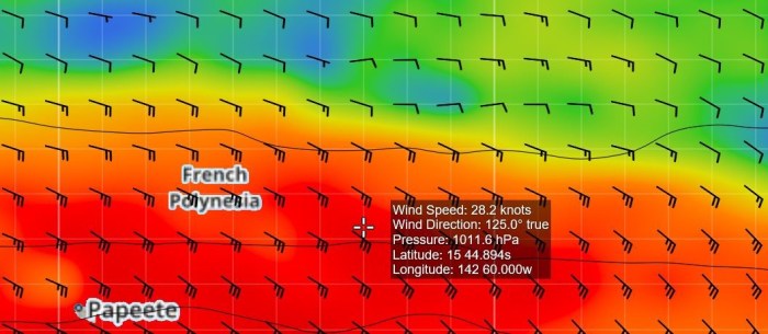
A weather map of the winds at Tuamotus. The curser (white cross) shows the local winds at the atolls – here 28 knots. The rolling high-pressure has reinforced the trades. This resulting in our delaying our passage two weeks.

The reinforced winds force the seas to rise, resulting in swells up to five meters. Here 4.2 meters.
All of the above does not paint a complete weather picture. To understand what will happen, weather-wise, over the next week or two, you need to understand what “The Beast” is doing. “The Beast” is the common name for the very unpopular South Pacific Convergence Zone (SPCZ). The SPCZ si not described in Danish books, nor is it mentioned in my “bible”, Meteorology and Oceanography for Ships Officers. Many unwary cruisers have has an unpleasant meeting with this weather system, which can create local winds up to hurricane strength. The question, is, what is “The Beast”? How is it formed?
“The Beast” is a large convergence zone, that is, a large area in the northwestern and central part of the south Pacific, stretching over the Solomans, Vanuatu, Samoa, Fiji, Tonga, The Society Islands and southward. This area is generally Characterized by unstable weather, lots of rain, thunder and lightning and very powerful winds and even stronger gusts. The wind here frequently “jumps” from one direction to another.

The Beast – SPCZ (South Pacific Convergence Zone)
The convergence zone is, as the name tells us, an area where large stable air masses converge. These air masses are homogeneous in that the air temperature and humidity are the same throughout. These air masses are formed there where homogeneous conditions occur – over large tropical oceans or Polar oceans. The masses don’t stand still, they are in constant movement due to the Coriolis effect (rotation of the earth). At the edges the wind is turned, so it either diverges, forming a high-pressure or converges, forming a low-pressure.
When the cold polar air mass moves over the warmer tropical ocean (cold air advection), the air is heated, a spontaneous convection occurs and the heated air rises. The heated air rises much as warm air bubbles, since the air around the bubbles is cooler. The warm and humid air will cool as it gets higher up in the atmosphere, eventually condensing and forming cumulus clouds – some with an anvil. The strength of the wind and the amount of rain, thunder and lightning this produces is dependent on how fast the bubbles cool down. If they cool more slowly that the air surrounding them, they will rise higher and faster, creating a more violent weather.
The cold air mass will eventually all have been heated and the convection will subside,, although it won’t cease. The effect will be like coals still glowing in a fire that has burned out. When a new low-pressure trough arrives and sends more polar air up in the atmosphere, the convection will start again. The polar air will “throw gasoline on the fire”.
Why does this SPCZ not reach all the way up to its “sister” in the Doldrums, the ITCZ? And why does it remain relatively stable over the northwestern part of the Pacific? The SPCZ is held in place by the stationary highs off the coast of Chile that send high-pressure winds up through the trade wind belt and, together with the trade winds, move a large mass of air towards the central and western Pacific. This air mass, moves across the warm tropical ocean, becoming homogeneously stable both in terms of temperature and humidity.
Every time a low-pressure trough comes in on the back edge of the high (as described above), it brings a cold polar air mass in with it. The front then moves northeast and while the winds in the southern portion of the front move faster towards the east, the northern winds will move more slowly and in a northerly direction. The further north the cold front moves, the more it will turn west and integrate itself with the warmer, wetter easterly winds from the stationary high and the trades, thereby forming a convergence zone.
As this convergence zone continues its northerly movement it will eventually stall as a stationary convergence zone stretching from the Solomans to the Cook Islands, with a “tentacle” stretching up to the Society Islands and Tahiti. This is due to the fact that the westerly atmospheric winds in the northern latitudes are weaker than the atmospheric winds in the more southerly latitudes. The winds are stronger the further south you move because the circumference of the earth becomes smaller the further south you go. The SPZC therefore, never “melts” together with the ITCZ.
The size of the SPCZ depends on the time of the year, becoming larger and stronger, reaching its peak in January and shrinking and weakening to its smallest size in July. The unstable weather in this area is not always violent or active, but if we are to sail this area, we need to keep a wary eye on approaching cold fronts that might “throw gasoline on the fire”. Getting caught when “The Beast” is active means hurricane force winds and gigantic swells. Many boats have been either lost or severely damaged in these storms.
The best advice? Stay far away from the SPCZ if possible.
That, of course, isn’t always possible. We all need to sail westward and when we pass longitude 140 we are in “The Beast’s” territory. Before sailing through here, the cruisers needs to find a good long weather window, thereby avoiding an active SPCZ. If the worst happens, we can’t expect the nasty weather to be “just” a squall where we grit our teeth and wait a few hours for it to pass. The SPCZ is relatively stationary, although its size varies (depending on the time of the year). If it becomes active, it is vital that we sail away from it as fast as possible, even though that action adds many nautical miles to our journey.
The above tells us that when crossing the Pacific, it is vital to have ensured a good weather window and important to download gribfiles at once per day to stay abreast of developing weather patterns.
Another fearsome situation is to get caught in a “Squash Zone”. Squash Zones are generally found at higher southern latitudes in the areas near New Zealand and the Tasmanian Sea. This situation occurs when a high-pressure area follows immediately behind a deep low, creating an area where the isobars are squeezed tightly together (isobars are wind indicators on a weather map). Tightly squeezed isobars indicated extremely strong local winds. There is a rule of thumb called 30 x 30 x30, that stands for; if you are south of latitude 30 in a high-pressure area measuring greater than 103 hPa, then you can expect winds exceeding 30 knots. In other words – gale force, or worse. Weather like that is best avoided and the best advice is simply to not be in the area when it occurs.
We’ve just received a weather update for Bob McDavitt, a New Zealand weather “guru” whose reports we subscribe to. Such a weather pattern is expected to form between Tahiti and Tonga. His advice is; Stay where you are – do not sail out. Most of the boat accidents between Tonga/Fiji and New Zealand occur in Squash Zones and not because of the pressure fronts.
The above challenges give cause for concern not only when we are sailing, but also when we are at anchor. There are few marinas out here, so there is no place to seek protection. Whether we are anchoring inside an atoll or in the lee of a volcanic mountain, it is important that we are aware of the best place to move anchor to if the worst happens.
While at the Tuamotus and the Society Islands, we experienced strong winds and heavy rains even though we were not in a Squash Zone or a front. The poor weather was caused by a rolling high-pressure area that passed over us, reinforcing the trade winds. This is a phenomena the Polynesians call “Mará umu”. These storms occur mainly in July, August and September.
A frequent topic of discussion here in the Pacific is the likelihood of an El Niño year. Most of us have heard of El Niño, a phenomena that occurs every third to seventh year. Actually, it occurs every year in December, but with varying strength and duration. Peruvian fishermen have for centuries observed that at Christmas time, the waters near the coast are warmer and the anchovies disappear. El Niño is Spanish and means “boy child” – named after the birth of Christ.
The warmer waters come from the west – but how does that happen when we know the Humboldt Current runs from east to west? Ocean currents are affected by the friction of the winds on the ocean surface. The east to west trade winds “push” the ocean water towards the west and it collects against the land at Darwin in northern Australia. The ocean surface near Darwin is thirty to forty centimeters higher than it is near Papeete on Tahiti. The water temperature (SST – Sea Surface Temperature) at the two locations is also different, causing a difference in the atmospheric pressure at the two locations. This difference is negligible in normal years and is expressed in the measurement SOI (Southern Oscillation Index).
The index indicates if a El Niño year is developing. A negative value, means the atmospheric pressure over the ocean at Darwin is higher than at Papeete, meaning an El Niño is possible/probable. But why?
In a normal year, the normally occurring El Niño current ceases after a couple of weeks in December, but if the following combination of circumstances occur – we will have a El Niño year:
- An unusually high SOI in the western Pacific and a lower SOI in the eastern Pacific and
- The trade winds are weak in the central and eastern Pacific and
- Unusually strong westerly winds blow from the western Pacific, forcing the warmer western waters to flow eastward along the equator.
- The normal strong southeasterly trade winds and the southeasterly winds from the stationary high (Chile) push the surface waters away from the Peruvian coast, allowing the colder waters from below to rise to the surface, creating the cold and nutrient-filled Humboldt Current. But a combination of the ITCZ (Doldrums) moving further south than normal, causing northerly winds while the trade winds are weak will allow the warmer waters to remain near Peru. This is why the anchovies seek colder water deeper down and disappear from the fishing areas, causing consternation amongst Peruvian fishermen.
- The warmer waters will cause massive rains along the west coast of South America and drought in Indonesia and Australia.
What does all this mean for cruisers? We can probably survive without anchovies.
In an average year, there are sixteen cyclones (hurricanes) in the Pacific, but in an El Niño year, there are twenty. The hurricane period doesn’t change, it is still officially from November to May, with most of the hurricanes occurring from December through April. In a normal year, these concentrate themselves in the Coral Sea, New Caledonia and Australia. In an El Niño year, however, they move further afield, coming eastward to Fiji, Samoa, Tonga and occasionally reaching even French Polynesia.
That means that if a strong El Niño year is developing, then cruisers in French Polynesia must be aware of the risk of hurricanes. If we are “overwintering” in the Tuamotus, Gambier or the Society Islands then we need to study the weather forecasts daily. If a hurricane is coming – then it is time to sail northward as soon and as early as possible.
Outside the hurricane season, a strong El Niño will normally precursor a sailing season with weak trade winds. The weaker trade winds might be a good reason to spend an extra year in Polynesia.
Tsunamis are a very real threat out here. There are many undersea earthquakes, although we seldom hear about them in weather forecasts. In 2016, the Marquesas were hit by a tsunami, which caused major damage on the pier at Hiva Oa.
Why are these weather phenomena not discussed in detail in Danish cruising guides? They are barely mentioned. Perhaps because cruisers tend to forget their bad experiences and only remember their good ones. Or perhaps because many do not understand the underlying causes and simply put their bad weather experiences down to bad luck.
As I’ve noted, I’m not a meteorologist, only an amateur sailor, but I hope that I been able to pass on our knowledge and experiences to other cruisers and help them understand that there are weather challenges out here that are not known to Danish cruisers.


This is a wonderful article and very invigorating.
Coincidently “SV Violet Hour” had something on a similar topic today in SE Alaska that I thought you might enjoy:
https://svviolethour.com/2021/05/24/learning-how-to-sail-in-southeast-alaska/#more-4442
This website is really a walk-via for all the data you needed about this and didn’t know who to ask. Glimpse right here, and you’ll definitely discover it.