A high altitude desert where one canyon leads to another
After having spent almost a month in Colorado, we left Mesa Verde and drove into Utah, home of the Mormons. Here, polygamy is still legal, meaning a man can have more than one wife. Today, most Mormons don’t practice polygamy, although there are still some fundamentalists who cling to the belief and have more than one wife.
Joseph Smith was the founder of the Mormon religion (1830). Some years later, he and his brother were jailed for treason. While they were incarcerated, a group of antimormons broke into the jail and murdered them. Brigham Young became the new leader of the Mormons. Legend has it that he was visited by an angel who bade him lead the Mormons from Illinois westward to find a new home. In 1847 the Mormons migrated to Utah, an area that was virtually only inhabited by the native indian population. Here they could practice their religion in peace. A large percentage of Utah’s population is still Mormon, although the greatest concentration is found in Salt Lake City.
The drive from Mesa Verde to Canyonlands National Park in southeastern Utah is actually boring. Only after we turn off the main road and onto the road leading the 55 miles into the park does the landscape become interesting. It is difficult to describe – it is almost as if we are passing into a fantasyland (ala Tolkien). Slowly we drive between the high red cliff walls that define the canyons.
About ten miles in we stopped at Newspaper Rock. Here we see 2000 year old petrography, etched into the rock there where seeping rainwater has colored the rock black. The Indians have etched their stories here, but no one can decipher them today. Many of the figures are carrying weapons and there are also depictions of animals, so likely they revolve around hunting.
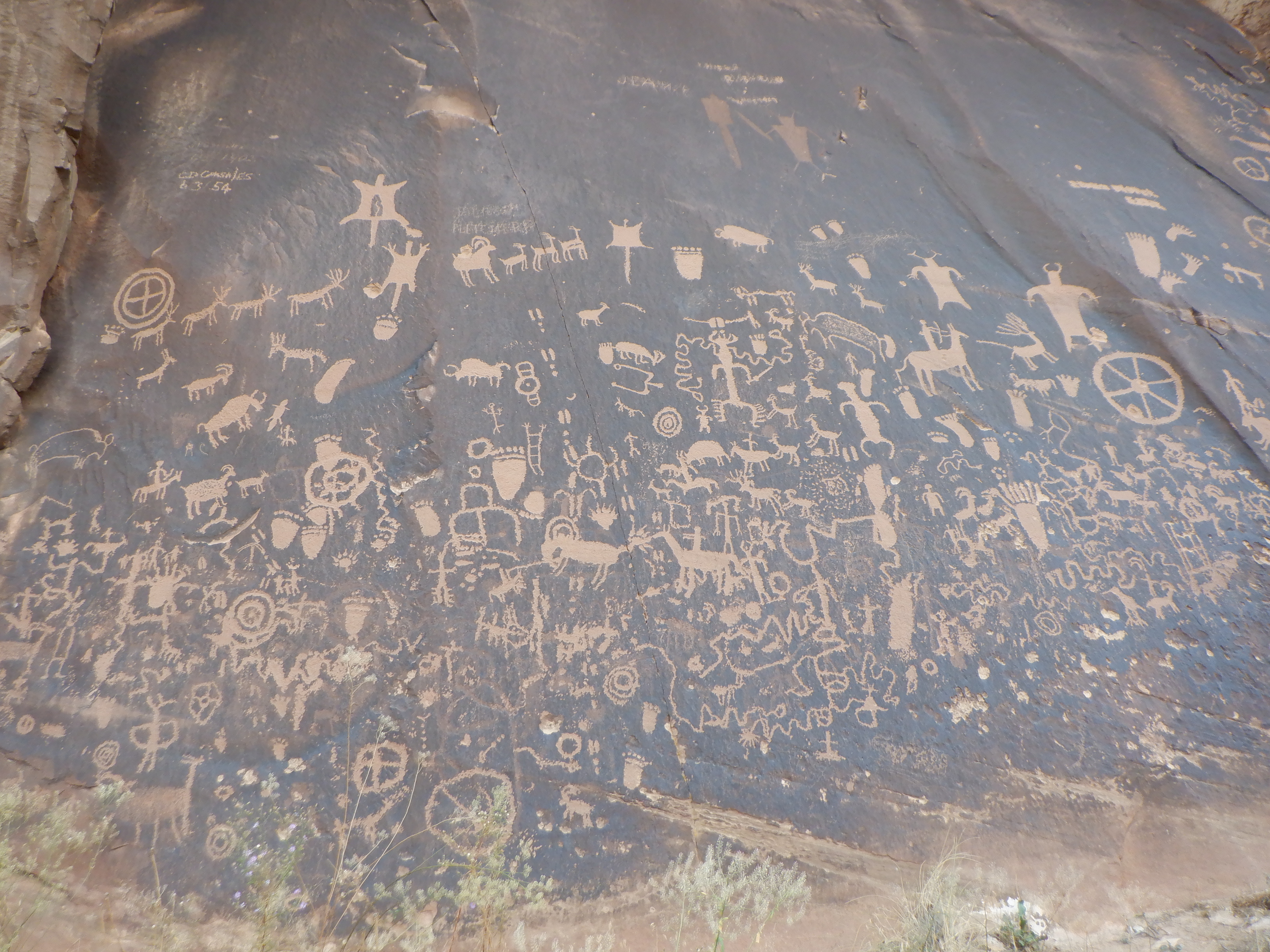
On this cliff wall deep in the alcove, the Indians etched their pictographs. Stories of their hunts as far as we can tell.
Canyonlands National Park is divided into two parks. The southern park is called The Needles and the northern park Islands in the Sky. There is no road that leads between the two parts as the canyon rich landscape is unsurpassable. One enters the southern part, then drive back out and 70 miles around to get to the northern entrance.
The Needles is aptly named for the rock formations here that look like many needles.

As I wrote above, it is 55 miles from the main road to the park entrance. There is a campground here, but it has only 24 spots. Half the spots are reservable and the other half are “first come – first served”. The reservable spots are all booked at least six months out. The park only has 140,000 visitors each year. Even so, the first come- first served are spots are all taken when we arrive.
Not to worry. The campground host tells us to go just outside the park and find a spot in Creek Pasture Campground, then come back in early the next morning and get a spot as someone leaves. This was good advice and we don’t regret having to spend a night in Creek Pasture. Our spot there was marvelous and the view of the mesas surrounding us surrealistic. The sunset alone was worth spending the night there.
The next morning we found a spot inside the park and probably had the spot with the best view of The Needles
Canyonlands, especially the southern part, The Needles, is extremely popular for the many hiking trails that meander through the untold canyons. Despite this popularity, there are few tourists here, probably due to the primitive conditions. There are toilets at the campground, surprisingly flush, but there are no other amenities. No electricity, no hook-ups, no black & gray water dumps. There are no restaurants or hotels – as a matter of fact, there is only the campground and a visitor’s center and nothing else.
140,000 visitors per year may seem like a lot, but compared with Arches National Park (3 million) and Canyonlands North (3 million), there is no one here. Rumor has it that Arches will start limiting the number of people admitted each day next year. This means that if you want to be sure to get in, you will need to reserve a time slot. This policy is more than a little controversial. After all, these are public lands, owned by the public – how can you limit the number of people who want to visit? But it is also about protecting the land and the natural wonders located here. The multitude of visitors, especially the great influx arising from these covid times, has stressed the land immensely.
Our first evening we went to an evening lecture at the amphitheater at the campground. A very knowledgeable Ranger held and interesting talk about how these lands were formed. The park is located in a high altitude desert. Normally, when we think of desert, we think about something like the Sahara. Here, however, there is no loose blowing sand, the area consists of red rock formations and many, many canyons.
The cliffs are mainly sandstone with large concentrations of minerals (iron gives the rock its red color, for example). Blue comes from magnesium and green from copper. The greater part of the rocks are red and when touched, feel a bit sticky. The stickiness comes from spores and bacteria in the air that have formed a type of crust, protecting the cliff from erosion. The rock still erodes, but much more slowly. The black color we occasionally see is from rainwater running down the side of the cliff.
Another crust we find here, keeps the sandy ground from blowing away. This crust is everywhere and looks like solidified mud.
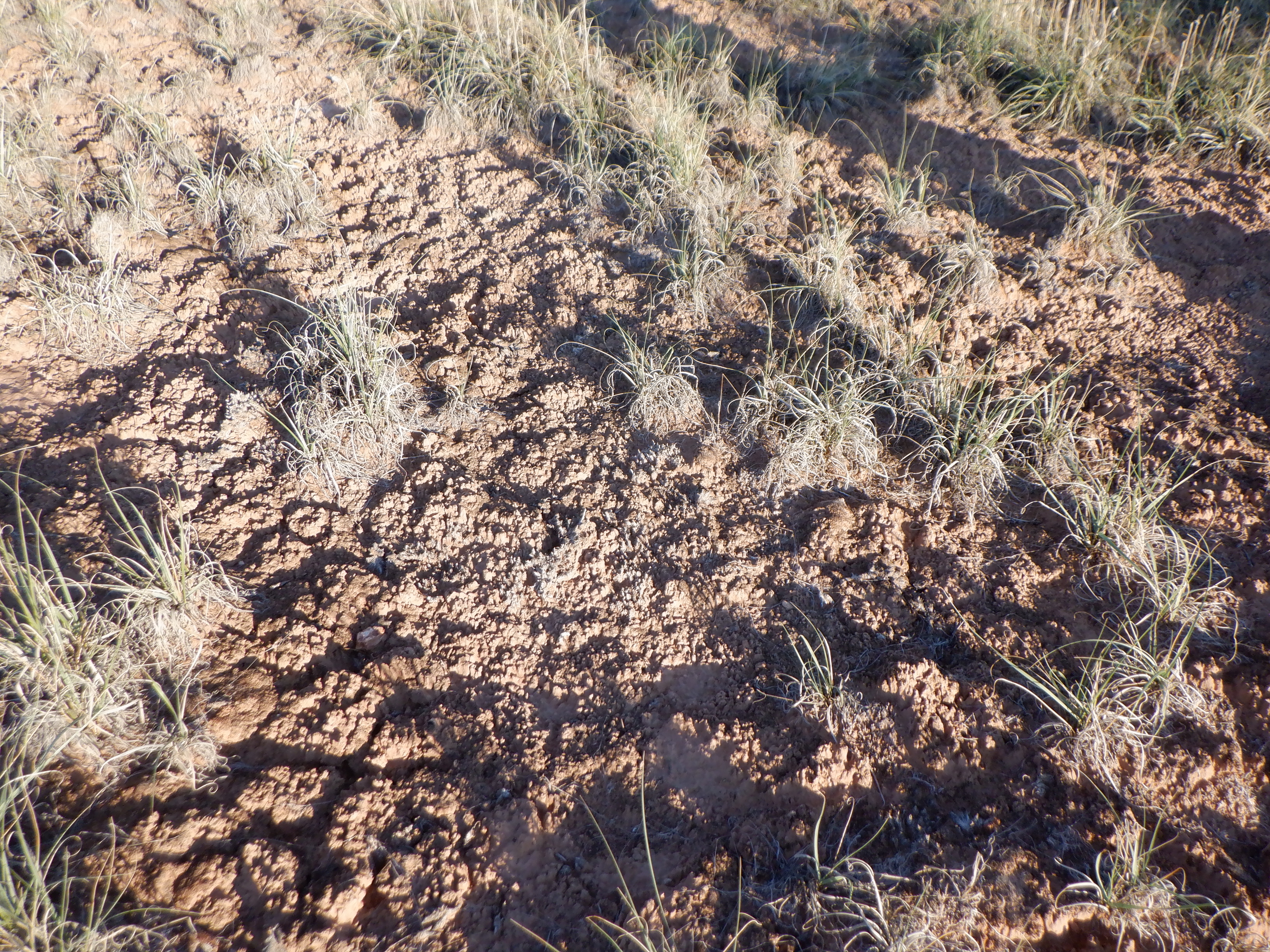
The Ranger tells us that when we are trekking to stay on the pathways. If we wander off, we will destroy the crust and erosion will immediately begin. The crust consists of living organisms, dominated by cyanobacteria (also known as algae). When the earth gets wet, these algae begin to move and leave a fiber-like net across the ground (almost like a spider web) that collects sand and dirt particles, resulting in a thick crust, that protects the ground. The crust acts as a sponge, absorbing the water and stopping erosion. Footsteps or vehicle tracks crush the crust and the protection is immediately lost.
The landscape is so inviting that we can barely wait to go exploring. Our first day we chose one of the shorter routes, a quick little trek of only 3 miles on Slickrock Trail. The hikers guide says this should take 2.5-3 hours. This is labelled an “easy beginners trail”. The trail will give us a chance to gain an overview over the landscape and “teach” us how to follow the cairns that mark the trails. Getting lost in this park is easy. Cairns, despite what the Ranger has said, are not always easy to spot in this terrain.

Afterwards, we take a short 1 mile trail out to Pothole Point. The visitors center has fantastic pictures of the “potholes” on this trail. Small waterholes on the top of the rocks filled with yellow flowers. The pictures were apparently taken in the spring – there are no flowers here now. Most of the potholes are dried out – this is autumn, after all. We were disappointed – but it was only 1 mile.
How can there be waterholes here in this rocky desert? Why doesn’t the water simply seep into the soft sandstone? Acid rain is the answer. The weak acidic rain that falls here, gathers on the rock surface and dissolves the outermost layer of sandstone, forming a depression. The microorganisms that live in the rain form a watertight film on the surface, prohibiting the water from seeping further into the rock.
We have reserved day two for the big trek out to the Needles and Druid Arch. The guide says the round trip is 8 miles, should take 6-8 hours and is labelled “strenuous”.

We’re at the start of the path bright and early the next morning. Bright and early, because the midday sun here is hot and it is best to get started while the temperatures are low. The Ranger warned us that we need to stay oriented in regards to the cairns. If we can’t see the next Cairn, stop then go back until we find the previous one and the start forward again. Only three weeks ago, a young man got lost on this exact trail and was first found 3 days later. He only survived because it had just rained and there were some puddles of water he was able to drink from.
The first couple of hours we walk on a narrow gravel and sand path, well-marked by frequent cairns alongside. The path begins to climb up, then down the rocky outcroppings. The campground is at 6,000 feet so the air here is much thinner than we sea level sailors are used to. Carsten and I have also started an Atkins diet a couple of weeks ago to lose some of the heavy baggage we have been carrying around. Atkins is a low carb diet so we have lower than normal sugar in our blood – and therefore less energy. We’re losing weight because soon we will be in New Mexico and we know we will end up eating lots of New Mexican food (heavy in carbs) and drinking more than our share of margaritas. Dieticians recommend that if you are on an Atkins diet, you should forego heavy physical exercise or exertion. So why are we busy trekking over high mountains? We’ll pay for this later on our hike.
We approach our first really high cliff wall. Hmmm – how are we supposed to get up this? Finally, Carsten yells, “I can see cairns all the way up the wall!” They can’t be serious. They can’t mean that we are supposed to climb up this almost vertical wall, skirting the edge of the rocks to get to the other side.
Our choices are climb or go back. Not being quitters, we climb. Some places it is so steep as to be almost vertical and we are happy that we are wearing our hiking boots that can get a good grip on the rock. We inch along, leaning in towards the rock face to keep from falling off. Many places the gap between the footings is so far that my short legs can’t reach and Carsten has to grab my arm and haul me over.
Out of breath and with acid in our leg muscles, we finally reach a small plateau. We look around for the cairns. None to be seen. We look again and finally I spot one near a cleft in the cliff wall. Looking in through the cleft, we can see the next cairn on the other side some 100 feet away.
I turn to Carsten “They are completely out of their minds! Carsten, they want us to go through this cleft. There is no floor and we have to walk with one foot on either side of a 20-foot drop. What the hell and I supposed to do? The cleft is much too wide – my legs aren’t long enough to have a foot on either side?”
“Besides, the cleft is so low that I can’t stand upright and there is nothing in there to hold to!”
Carsten starts through the cleft to show me how to negotiate it. Halfway through my sweet husband turns and holds on to me so I can follow him. He makes sure I can feel he has a solid hold on me as I jump from one side to the other. My heart is pounding as we near the opening in the other end. Here we come out on a small plateau and it is at least 6 feet down to the next level. Neither one of us wants to make that jump. Carsten looks around and spots an old tree trunk that is wedged in between the rocks. The Rangers have cut some footholds in it and it is the “ladder” that we are going to use to get down. My legs are again too short to reach from one foothold to the next and Carsten has to grab my foot and guide from one chop to the next chop. I can’t thank Carsten enough, because without his help I would never have gotten down that tree trunk.
Safely on the other side of the cleft, we near us The Needles. We’re not quite there yet, we need to climb one more wall. Ahead of us, we can see a ladder so the first part of this climb should be fairly easy. People with vertigo should not trek here. Beyond the ladder, the path continues its steep climb. The cairns are few and far between here. Looking down from an outcropping, we can see another ladder so obviously we need to get down there.
But how?
The ladder below us goes downward from an outcropping about 10 feet down. There is no ladder here to get down there. We march back and forth on our little ledge looking for the way down.
We keep looking but there doesn’t seem to be any way down until Carsten leans out over the edge and says, “Well, I found the way down, but you won’t like it.” Leaning out, Carsten can see that the Rangers have cut some hand and foot holds in the side of the cliff. Of course, these are not very deep. In fact, they are just barely deep enough to stick your toe or three fingers in.
Carsten goes over the edge and starts down. He quickly realizes that the footholds are spaced too far apart for my (once again) short legs. Damn it! I was born this way – it is not my fault I have short legs!
This will be a huge challenge for me. I’m almost ready to cry. I’m scared witless at the thought of crawling down the sheer cliff, even with Carsten helping me. I can easily imagine my foot slipping and both Carsten and I falling down onto the rock ledge below us, both of us breaking our backs or legs or something. My imagination is running wild and the thoughts are very real to me.
There really isn’t any choice. Going back is not an option. Once through the cleft is more than enough for me. I lie down and lean into the cliff as tightly as I can, then let my foot start down, searching for the first foothold. Carsten has hold of my foot and guides it into the first foothold. My legs are shaking.
I’ve never before been afraid of doing something physical. This time I am scared to death. The next foothold is far out to the side and far down. I’ve nothing to hold on to and all I can do is lean as hard as I can into the cliff. My voice is breaking and I whisper, “I’m afraid and I don’t think I can do this.” Carsten relies with a voice oozing with calm, “Not to worry, sweetheart, I’ve got a good hold on you. I won’t let go.”
Somehow, we both get down without any accidents, thanks to Carsten’s courage and calm demeanor. I’ve never been in that kind of situation before and I certainly hope it never happens again.
The trekking guide notes that on this path, you need to climb up (or down) two ladders, but it says nothing about a 10 foot sheer cliff with no safety net or handholds. I’m completely destroyed, my fear has drained all the energy out of me, but the view of the Needles from here helps me recover – especially after we get safely down ladder number two.
We’ve reached the Needles are now hiking past them at their bases. These sharply pointed stone formations have been formed by erosion. Millions of years of rain have washed away the looser sandstone and formed these spires. Along the way, we see stone formations that can easily be mistaken for giant mushrooms. The cliffs here have several types of rock in various strata. The uppermost strata is of a hard rock that is better able to withstand erosion. Further down, the red sandstone is not as resilient and erosion has washed away the stone leaving a thinner “stem” underneath the mushrooms “hat”.
Having finally passed the Needles and regained some energy, we are ready to begin the next climb.
Our plan (yes we actually have one), is to trek the rest of the way out to Druid Arch to see this magnificent arch nature has created. These arches are formed mainly by wind erosion. Part of the way there, the path is supposed to be deep sand and the last quarter mile or so, very steep. I look at Carsten and beg off on that part of the trip. The cleft and the sheer rock cliffs have taken all my energy and resolve. We drop the final couple of miles out to Druid Arch. We still have 4+ miles to go and will climb at least three more mountain ridges before we are back at the campground.
This part of the trek is in a dried out creek. The cairns here are few and far between. For a longish stretch, there are no cairns. We go back and forth several times trying to find a cairn that will show us the way.
Nothing.
Suddenly, we can’t believe our eyes. A young man comes running up the creek towards us. Running. This is really broken field running. We stop him and ask if we are lost? Where is the next cairn. He apologizes for the missing cairns (we suspect he is a park ranger out for a morning run) and tells us that the cairns have probably been washed away in a recent rainstorm. We are perfectly on course, he says. About 100 yards up ahead there is a signpost showing directions to Druids Arch and back towards the campground.
We’ve been trekking for over six hours and he is the first person we have seen. At the signpost, we are suddenly in the midst of hoards of people. They have chosen the tourist route – a much easier and gentler hike. We trek on the tourist route for about a half hour, then turn off on a path heading back to the campground. This path, is not a tourist route and we will meet no one for the remaining 4 miles back to the campground.
Those last 4 miles up and down over mountain ridges are the longest 4 miles I ever walked or crawled in my life. Will this punishment never end? Never have I been happier than when we spotted the campground out in the distance.
We’ve had an indescribable experience, trekked through a unique landscape, enveloped in total silence. With the exception of the half hour on the tourist route, we were totally alone, on a strenuous trek through the wilderness. Would we (I) do it again? Yes, but not tomorrow. The acid in our legs has to disappear first and my pulse has to drop to normal levels again. Now that I know what awaits me, I might be convinced to try it again, but only if Carsten goes along.
Our last day here we visit Cave Springs. Here, the trek is only 50 years or so to see a cowboy camp from the days when the ranchers had cattle grazing here. In the late 1800’s the ranchers drove their cattle out here into Canyonlands where the cattle could graze on the open range. The cowboys made camp where they could, the major criteria being water. Here at Cave Springs, they made a semi-permanent camp in a shallow cave where they were protected from the elements. At one end of the long cave there is a seeping spring coming out of the wall, forming a small pool. This constant supply of water meant the camp was livable for both them and their horses.
On our way in towards the parka and several other places, I’ve seen a sign saying “open range”. Open range means there are no fences out here and the cattle range freely. Each fall, the cowboys ride out and round up the freely roaming cattle (no I am not kidding – we’ve seen several cowboys on horseback, complete with lasso etc. driving cattle toward a corral. The Park Ranger warned us that driving across the open range at night could be a dangerous proposition. Hitting at half ton black cow at night is “sure to ruin your vacation”.
After these unimaginable experiences, we pack up and leave Canyonlands. It is difficult to believe that we will experience anything that will top this. Our plan is to drive north to Canyonlands North (Islands in the Sky) and Arches National Park. As usual, the best laid plans of mice and men oft go awry and that will also be true for us. Carsten will write about our further misadventures in the next blog.


Vinni, you are a braver woman than I!!! I am sorry you did not come to the reunion in September. I was so looking forward to meeting you! It would have been the icing on the cake to have met you and talked! Was good to see you Carsten, though we didn’t have a ton of time to talk. Another time! Safe travels!